
Why Logger
WHY Logger
Current version: 2.9.37
WHY Logger is a lightweight Windows contest logger for VHF, UHF and microwave operation, primarily developed for the Swedish NAC contests.
Version 2.9.37 combines fast contest logging with integrated mapping, propagation tools, beacon monitoring, Aircraft Scatter support and direct ON4KST access — while keeping the program simple and practical to use during a contest. Now also with waterfall.
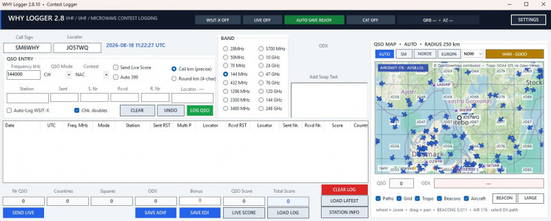
Main features
- NAC, SM-Open and SM-Micro contest logging
- Bands from 28 MHz to 248 GHz, including microwave bands
- Automatic scoring, multipliers and duplicate checking
- REG1TEST / EDI export per band and ADIF export of the complete log
- ODX, Maidenhead square (WWL) and DXCC tracking
- Interactive OpenStreetMap QSO map with QSO/ODX paths, Maidenhead grid and offline fallback
- Separate resizable Large Map with AUTO, SM, NORDEN and EUROPA views
- Band-aware tropo potential overlay using NOAA GFS via Open-Meteo, with NOW to +12 h forecast views
- Band-filtered beacon overlay using IARU Region 1, SSA and community/HEARD data plus local beacon entries
- Clickable beacon information and IC-9700 beacon tuning on native 144/432/1296 MHz
- Integrated Aircraft Scatter with live aircraft display, path analysis and WATCH / GOOD / VERY GOOD / PRIME indication
- Automatic aircraft data fallback between multiple ADS-B providers
- ON4KST client integrated directly into WHY Logger
- Structured ON4KST chat with correct From / To information
- ALL KST and MY MESSAGES views for easier contest operation
- Online KST user list with locator, QRB, bearing and last-seen information
- Select a KST station directly as an Aircraft Scatter target
- Online-first callsign and locator lookup using HamQTH/HamDB with local callbook fallback
- Check Partial and N+1 callsign suggestions
- WSJT-X UDP Auto-Log
- IC-9700 CAT readout and automatic native-band selection
- Live QRB and antenna bearing
- Live Score reporting to SLOVHF
- Autosave, snapshots and crash recovery
Download
WHY Logger 2.9.37
why-logger-2-9-37.zip
No installation is required. Unpack the ZIP file and run WHY Logger.exe.
At first start, enter your own call sign and locator. Operator and station information can be entered under STATION INFO.
Information of the Maidenhead system from ARRL.
About Grid Locators and Grid Squares
An instrument of the Maidenhead Locator System (named after the town outside London where it was first conceived by a meeting of European VHF managers in 1980), a grid square measures 1° latitude by 2° longitude and measures approximately 70 × 100 miles in the continental US. A grid square is indicated by two letters (the field) and two numbers (the square), as in FN31, the grid square within which W1AW, ARRL's Maxim Memorial Station, resides. Each subsquare is designated by the addition of two letters after the grid square, as FN44ig. These more precise locators are used as part of the exchange in the 10-GHz contest. They measure 2.5 minutes latitude by 5 minutes longitude, roughly corresponding to 3 × 4 miles in the continental US. The Lab Notes column in April 1994 QST covered grid squares in particular and geographical coordinates in general.
The program is free. If you want to donate for further developement:
Welcome
Welcome to sm6why.n.nu.

My Newsletter
Links